Morecambe to Bridlington (WOTR) and a bit extra - September 2012
If you don’t want to read the full account of the ride please scroll to the bottom for a brief summary and a list of tips that you may find useful
Day 1
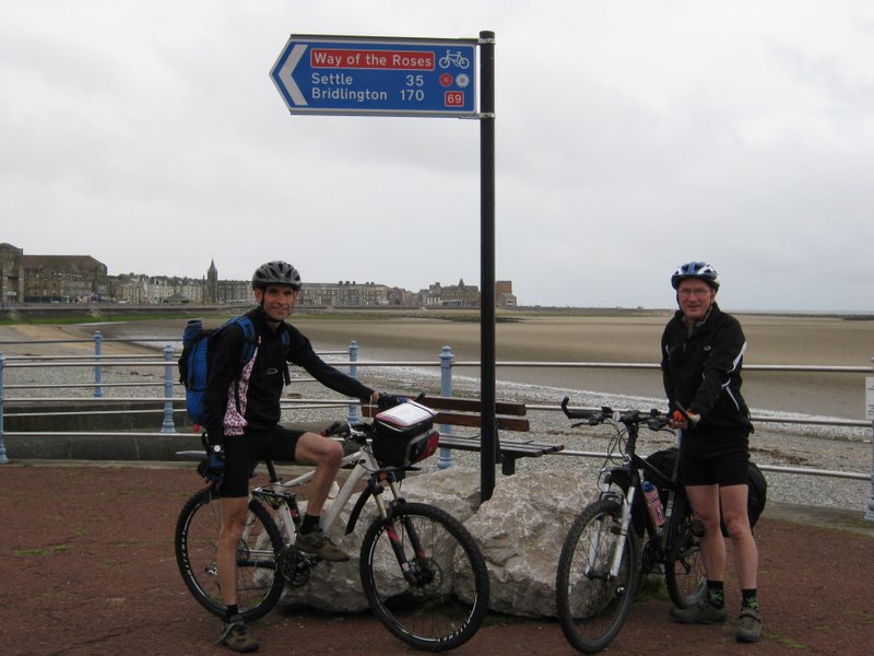
We arrived in Morecambe at around 10.20 having been driven over from the north-east by my brother’s wife. After sorting out our gear whilst having a coffee and the first of many chocolate bars (no fancy cafes for us!) we took the obligatory photograph at the starting point (two big rocks with a WOTR sign) and set off into the wind.
The route was well signed out of Morecambe and in no time we found ourselves in Lancaster travelling along a cycle path beside the very pretty River Lune. We weaved our way along some very quiet and pretty Lancashire lanes with only a few small climbs and the odd light shower to slow us down and before we knew it we had passed into Yorkshire at the 20 mile mark.
Our only major mistake of the day came just after we had crossed the very busy A65 (which was quite frightening after so many quiet/car free miles) and rode through Clapham. We missed the far from obvious sign pointing to the off-road section through the two tunnels and instead followed another route 68 sign which took us in the opposite direction towards Ingleton. Thinking we were going the correct way we merrily cycled uphill (why do mistakes always end up taking you uphill?) and stopped at the top. Breaking for lunch we perused the map and, turning it the way we thought it went, found it didn’t fit what we could see! We realised we had gone wrong and fortunately we met a helpful local who pointed us in the right direction – but it was a lesson learned – don’t always assume that the signposting is perfect and you’ll get to your destination without periodically stopping to check the map. Back on track we found the two off-road tunnels and attempted to ride through them but found the rough surface too wet and slippy for our pumped up tyres. We decided to get off and push for about ½ mile in total until the surface improved. After a short while we came out at a T-junction which wasn’t signed in any way at all. Consulting the map we guessed our route turned left and after a mile or so we met another local who confirmed that we were indeed heading in the right direction this time. To be honest we both felt, because of this poor signing and the surface of the track, that we would have been better not doing the off road section at all and taking the alternative route on the map instead, taking in a short section of the A65 before turning left into Austwick.
Carrying on we climbed steadily to reach the pretty town of Settle, somewhere I was aware of but have bypassed in my car on the A65 - it’s amazing how much more you see of a place by going by bike. We found the signing through Settle to be quite confusing and a local lady asked us if we were lost. She gave us directions to the “big hill” (again not very well signposted) and then corrected us again. Setting off in trepidation (we had heard stories of how steep it was) we were both pleasantly surprised - we both rode it! This was the steepest hill of the ride and we both felt it was easier than the those we had encountered on the second day of our first coast to coast (the original Whitehaven to Sunderland route) and also on bits of last year’s ride, the Walney Island to Whitby coast to coast ride.
Once over the top we headed downhill into Airton and got a couple of “free” miles where we didn’t have to pedal much. Cracoe and Grassington came and went and we soon found ourselves on the highest and most exposed part of the ride near Stump Cross Caverns and Bewerley Moor. We sped down the infamous GreenHow Hill bank into Pateley Bridge where we were staying for the night. Again, we had read much about how dangerous this was, and expected to see wiped-out cyclists strewn across our path but in reality keeping our speed down to a sensible 25mph on the straighter bits and 15mph round the bends meant that we had no problems. We stayed at the cycle friendly Bewerley Hall Farm where we were met by owner Jonny, a keen cyclist himself, who told us about what lay ahead on the next day. After a quick shower we walked the mile into Pateley Bridge and had an excellent meal of local sausages and mash at the Royal Oak pub.
Day 2
Refuelled by tea, cereals, toast and a hearty cooked breakfast (we’d paid for it so we felt obliged to eat it was our philosophy) we set off into the drizzle from Pateley Bridge at around 9.45. The sun soon came out as we passed the interesting rock formations at Brimham Rocks. We were held up for about 20 minutes as a herd of cows were being moved from the dairy back to the fields, but before we knew it we were at Fountains Abbey riding down the long, wide, tree-lined drive at Studley Royal and through the rather grand entrance at the bottom. We stopped briefly to take photographs and admire the view and then headed into Ripon centre where we stopped for a drink at a small coffee shop just opposite the cathedral - where I left my wallet and was just caught by the cafe owner as I was about to pedal off – phew!!
The small, pretty market town of Boroughbridge was our next stop where we picked up our daily “meal deal” lunch at the Co-op (we like to do these rides on a budget!), before stopping for lunch at Lower Dunsforth. After cycling for a few flat and easy miles, through some beautiful countryside and very tidy villages, we made another short diversion (for more coffee and cake) at Linton-on-Ouse to visit a friend of mine who lives at Tollerton, just a couple of miles off the route. Suitably refreshed we pushed on into York, cycling alongside the River Ouse and into the centre. We found the signing to be a bit vague at this point and just headed for York Minster which we knew was central. We dodged and weaved our way through all of the tourists on a beautifully sunny day and eventually emerged on the other side of York after negotiating some quite busy roads. The next section followed flat, traffic-free cycle paths and we commented on how nice it must be to be able to ride in to work every day through such nice scenery and not be worried about getting knocked off your bike.
Stamford Bridge came and went and we then had a long (or it certainly felt that way as I had quite a “numb bum” by this stage) 8 miles into our overnight stop at Pocklington. Somehow we missed a turn and came out onto the A1079. After consulting the map we realised that the quickest way was to go along this busy A-road for a couple of miles (fortunately, there was a pavement we could cycle along). As we got into Pocklington I looked at my handlebar bag to get the directions to the B&B to find that I had lost both the Way of the Roses map and the North York Moors and Coast map for our fourth day (as well as the directions to the B&B). I knew the B&B we were staying at began with an “A” and it was something to do with a canal!! We asked some locals and they suggested a few places to look and we then spent 30 minutes riding round trying to find where we were staying to no avail. Eventually after ringing home, my wife managed to find the name & address of the B&B on the internet and we rolled in at about 7:30, cold and tired.
Fortunately Andrew had had the foresight to copy onto A4 paper and laminate all of the main sections of the map that we would need for the whole trip; this had several advantages – firstly they were fully waterproof and were easier to read than unfolding the big map and also we could continue without having to rely on us spotting the appropriate signs en-route. Highly recommended!
Day 3
Our start was slightly delayed due to the repercussions of a rather too hot curry the night before but we managed to get away for around 10.00am. We headed back into the centre of Pocklington and picked up the route again and soon found ourselves steadily climbing through a beautifully quiet valley bottom with virtually no traffic at all – not to mention a road surface that was better than most main roads. This climb, towards Huggate was the only one of any significance on the day and surprisingly our legs felt fine.
More quiet villages came and went and the scenery changed again to vast, flat, open, arable fields – at times the route just seemed to take us round all four sides of these fields for no apparent reason other than to get the miles in, but it was pleasant riding nonetheless. Tibthorpe and Hutton Cranswick were quickly despatched before stopping to buy another “meal deal” lunch special – this time at Tesco in Driffield where we had an interesting conversation about cycling with the very friendly till operator. At this point it was great to see signs saying “Way of The Roses and Bridlington – 18 miles”, the end was in sight; at least it would have been had we not been doing a fourth day and another 60 to 70 miles!
Just north of Burton Agnes we left the main WOTR route, satisfied that we could have made the remaining 7 miles to Bridlington if we had wanted to, preferring to push on to Scarborough. At this point the wind and the rain got up and we stopped in a bus shelter in Rudston for lunch. After half an hour the rain had just about stopped so we decided to push on for the final stretch. We had gone about a mile or so when the heavens opened again and, as we couldn’t find any cover, we had to cycle on through what I think were the worst conditions I have ever ridden in. We eventually stopped in Hunmanby, sheltering under a tree, only to get sprayed every 10 seconds by cars belting up a narrow road which could only be described as having a river running down it!
Deciding that the rain wasn’t going to stop, and as we were by now soaked through, we decided to carry on. The final official routed section into Scarborough (following National Cycle Network Route 1 can only be described as, on the day we rode at least, horrible. Although it was only a relatively minor road, cars and lorries seemed to fly by every few seconds at ridiculous speeds (considering the road was flooded on each side), with no consideration for two wet, tired and consequently wobbly cyclists – not a pleasant experience Sustrans! The rain by now had started to ease and the wind had got up which had dried us out but cooled us down even more - the outskirts of Scarborough were therefore a very welcome sight. Pausing briefly for photographs at the bridge at the top end of the South Bay (opposite the Grand Hotel) we cycled downhill and made our way past the amusement arcades and fish and chip shops and then via the long and exposed promenade between the North and South bays.
Feeling very cold and wet we arrived at the bed and breakfast (which overlooked the cricket ground) in Scarborough at around 5.30. The owners of the Ainsley Court Guesthouse were very friendly and helpful and we got the cheapest B &B of the week (and also the biggest breakfast) – for just £22.50 each. After arranging our wet clothing on the radiators to dry, we ventured into the town, working out the best route to pick up the trail for the following day. We found it in the corner of Sainsbury’s car park. After some good cheap beer and a meal in Wetherspoon’s we were ready for bed.
Day 4
Setting off at around 9.30 we were glad we had spent some time the previous evening figuring out the route out of Scarborough centre as we managed to pick up the disused railway line leading to Whitby quite easily. We bought up the obligatory ‘meal deal’ in Sainsbury’s and then joined the route out of the back of the car park. The “Trailway” as it is initially called (later referred to as the “Cinder Track”) has a slightly uphill profile for the first half of its 22 miles and I found it surprisingly hard going as it was mainly tree-lined and there was nothing to see to take my mind off my fatigue - it was also very busy with other walkers and cyclists (we saw more cyclists between Scarborough and Whitby than we saw on all of the WOTR). At Ravenscar we were treated to a teacher telling his field trip class all about “Ravenscar, the town that never was” – very interesting! After Ravenscar a bit more of the coast became visible and the gradient turned in our favour resulting in us reaching the outskirts of Whitby after about two and a bit hours. Rather than going right into Whitby centre we turned off at the old railway viaduct crossing the River Esk and headed down the hill into Ruswarp.
After making our way up a steep uphill off-road section (well surfaced but rideable) we reached the village of Aislaby and stopped for lunch. Our route then followed the reverse of our previous years Walney to Whitby ride - National Cycle Network signs for route 165 through Egton and Danby. This section wasn’t too hilly but we found it hard going due to a very strong headwind (we even had to pedal to go downhill) and tired legs. The scenery was very different to the huge, flat, arable farming fields of the Wolds with a patchwork of small green stone-walled fields, littered with sheep and cows, sloping down to the valley bottom.
We arrived at Castleton at around 4pm and stopped for a celebratory coffee and a big slab of cake in the tea shop in the centre of the village. This is a popular stopping point for cyclists and there are usually bikes propped up outside but today we were the only pedal powered visitors. Suitably refreshed and re-energised we set off down to the railway station and then up the unexpectedly steep hill (just made it) out of Castleton. Turning off, halfway up the bank, we went along the fairly flat off-road track leading to Commondale, where again there was another sting in the tail incline. After a few more ups and downs riding into a strong headwind we eventually arrived at Great Ayton and were at my house in Middlesbrough for around 5.45pm. Mission Accomplished (for another year!).
For Info
We both travelled on mountain bikes with Schwalbe Land Cruiser tyres pumped up hard. My brother had a pannier rack and panniers fitted and I carried a small rucksack (not recommended) and had a handlebar bag.
We used the Sustrans route maps (Way of The Roses) and North Yorkshire Moors and Coast – both recommended as although the routes are signposted there were several points on the WOTR in particular where signs were missing and we found ourselves looking at the map. As the roads are very minor, there are often no road signs to help.
Navigational Points to Note
Take Care at Clapham – watch out for the sign just before the big church pointing to the right and the off-road tunnels – it is very easily missed. Alternatively, turn right immediately after the A65 crossing and take the minor road which leads to Austwick (albeit via the busy A65 for a short section). In some ways the off-road section through the tunnels is possibly best avoided as it is quite rough and very slippy in the wet, certainly initially. Most people will struggle on it without suspension mountain bikes and knobbly tyres running at low pressure.
If you do take the off-road section through the tunnels at Clapham, when you reach the T-junction at the end of the rough lane turn left (the sign was missing), turning right will take you back to Austwick.
How does the Way of The Roses compare with other coast to coast routes?
We did the W2W (Walney to Whitby – although there is the option to finish in Sunderland at the River Wear) last year and the original C2C (Whitehaven to Sunderland) the year before that. Personally I found the WOTR to be slightly easier than the W2W and the C2C in terms of hills but obviously at 170 miles it is further than the C2C (136 miles), although not necessarily in terms of time spent in the saddle. Scenery wise it is perhaps the nicest of all three, taking you through some really pretty villages and countryside and, apart from the section from Settle to Greenhow Hill bank, it’s not too exposed. Signposting is generally good – although not perfect (I would say the original C2C is best for this so I would recommend buying the official WOTR map) and there are plenty of places to find accommodation. Either way, whichever coast to coast option you choose, I don’t think you will be disappointed.
Martin and Andrew Webb
September 2012
Day 1
We arrived in Morecambe at around 10.20 having been driven over from the north-east by my brother’s wife. After sorting out our gear whilst having a coffee and the first of many chocolate bars (no fancy cafes for us!) we took the obligatory photograph at the starting point (two big rocks with a WOTR sign) and set off into the wind.
The route was well signed out of Morecambe and in no time we found ourselves in Lancaster travelling along a cycle path beside the very pretty River Lune. We weaved our way along some very quiet and pretty Lancashire lanes with only a few small climbs and the odd light shower to slow us down and before we knew it we had passed into Yorkshire at the 20 mile mark.
Our only major mistake of the day came just after we had crossed the very busy A65 (which was quite frightening after so many quiet/car free miles) and rode through Clapham. We missed the far from obvious sign pointing to the off-road section through the two tunnels and instead followed another route 68 sign which took us in the opposite direction towards Ingleton. Thinking we were going the correct way we merrily cycled uphill (why do mistakes always end up taking you uphill?) and stopped at the top. Breaking for lunch we perused the map and, turning it the way we thought it went, found it didn’t fit what we could see! We realised we had gone wrong and fortunately we met a helpful local who pointed us in the right direction – but it was a lesson learned – don’t always assume that the signposting is perfect and you’ll get to your destination without periodically stopping to check the map. Back on track we found the two off-road tunnels and attempted to ride through them but found the rough surface too wet and slippy for our pumped up tyres. We decided to get off and push for about ½ mile in total until the surface improved. After a short while we came out at a T-junction which wasn’t signed in any way at all. Consulting the map we guessed our route turned left and after a mile or so we met another local who confirmed that we were indeed heading in the right direction this time. To be honest we both felt, because of this poor signing and the surface of the track, that we would have been better not doing the off road section at all and taking the alternative route on the map instead, taking in a short section of the A65 before turning left into Austwick.
Carrying on we climbed steadily to reach the pretty town of Settle, somewhere I was aware of but have bypassed in my car on the A65 - it’s amazing how much more you see of a place by going by bike. We found the signing through Settle to be quite confusing and a local lady asked us if we were lost. She gave us directions to the “big hill” (again not very well signposted) and then corrected us again. Setting off in trepidation (we had heard stories of how steep it was) we were both pleasantly surprised - we both rode it! This was the steepest hill of the ride and we both felt it was easier than the those we had encountered on the second day of our first coast to coast (the original Whitehaven to Sunderland route) and also on bits of last year’s ride, the Walney Island to Whitby coast to coast ride.
Once over the top we headed downhill into Airton and got a couple of “free” miles where we didn’t have to pedal much. Cracoe and Grassington came and went and we soon found ourselves on the highest and most exposed part of the ride near Stump Cross Caverns and Bewerley Moor. We sped down the infamous GreenHow Hill bank into Pateley Bridge where we were staying for the night. Again, we had read much about how dangerous this was, and expected to see wiped-out cyclists strewn across our path but in reality keeping our speed down to a sensible 25mph on the straighter bits and 15mph round the bends meant that we had no problems. We stayed at the cycle friendly Bewerley Hall Farm where we were met by owner Jonny, a keen cyclist himself, who told us about what lay ahead on the next day. After a quick shower we walked the mile into Pateley Bridge and had an excellent meal of local sausages and mash at the Royal Oak pub.
Day 2
Refuelled by tea, cereals, toast and a hearty cooked breakfast (we’d paid for it so we felt obliged to eat it was our philosophy) we set off into the drizzle from Pateley Bridge at around 9.45. The sun soon came out as we passed the interesting rock formations at Brimham Rocks. We were held up for about 20 minutes as a herd of cows were being moved from the dairy back to the fields, but before we knew it we were at Fountains Abbey riding down the long, wide, tree-lined drive at Studley Royal and through the rather grand entrance at the bottom. We stopped briefly to take photographs and admire the view and then headed into Ripon centre where we stopped for a drink at a small coffee shop just opposite the cathedral - where I left my wallet and was just caught by the cafe owner as I was about to pedal off – phew!!
The small, pretty market town of Boroughbridge was our next stop where we picked up our daily “meal deal” lunch at the Co-op (we like to do these rides on a budget!), before stopping for lunch at Lower Dunsforth. After cycling for a few flat and easy miles, through some beautiful countryside and very tidy villages, we made another short diversion (for more coffee and cake) at Linton-on-Ouse to visit a friend of mine who lives at Tollerton, just a couple of miles off the route. Suitably refreshed we pushed on into York, cycling alongside the River Ouse and into the centre. We found the signing to be a bit vague at this point and just headed for York Minster which we knew was central. We dodged and weaved our way through all of the tourists on a beautifully sunny day and eventually emerged on the other side of York after negotiating some quite busy roads. The next section followed flat, traffic-free cycle paths and we commented on how nice it must be to be able to ride in to work every day through such nice scenery and not be worried about getting knocked off your bike.
Stamford Bridge came and went and we then had a long (or it certainly felt that way as I had quite a “numb bum” by this stage) 8 miles into our overnight stop at Pocklington. Somehow we missed a turn and came out onto the A1079. After consulting the map we realised that the quickest way was to go along this busy A-road for a couple of miles (fortunately, there was a pavement we could cycle along). As we got into Pocklington I looked at my handlebar bag to get the directions to the B&B to find that I had lost both the Way of the Roses map and the North York Moors and Coast map for our fourth day (as well as the directions to the B&B). I knew the B&B we were staying at began with an “A” and it was something to do with a canal!! We asked some locals and they suggested a few places to look and we then spent 30 minutes riding round trying to find where we were staying to no avail. Eventually after ringing home, my wife managed to find the name & address of the B&B on the internet and we rolled in at about 7:30, cold and tired.
Fortunately Andrew had had the foresight to copy onto A4 paper and laminate all of the main sections of the map that we would need for the whole trip; this had several advantages – firstly they were fully waterproof and were easier to read than unfolding the big map and also we could continue without having to rely on us spotting the appropriate signs en-route. Highly recommended!
Day 3
Our start was slightly delayed due to the repercussions of a rather too hot curry the night before but we managed to get away for around 10.00am. We headed back into the centre of Pocklington and picked up the route again and soon found ourselves steadily climbing through a beautifully quiet valley bottom with virtually no traffic at all – not to mention a road surface that was better than most main roads. This climb, towards Huggate was the only one of any significance on the day and surprisingly our legs felt fine.
More quiet villages came and went and the scenery changed again to vast, flat, open, arable fields – at times the route just seemed to take us round all four sides of these fields for no apparent reason other than to get the miles in, but it was pleasant riding nonetheless. Tibthorpe and Hutton Cranswick were quickly despatched before stopping to buy another “meal deal” lunch special – this time at Tesco in Driffield where we had an interesting conversation about cycling with the very friendly till operator. At this point it was great to see signs saying “Way of The Roses and Bridlington – 18 miles”, the end was in sight; at least it would have been had we not been doing a fourth day and another 60 to 70 miles!
Just north of Burton Agnes we left the main WOTR route, satisfied that we could have made the remaining 7 miles to Bridlington if we had wanted to, preferring to push on to Scarborough. At this point the wind and the rain got up and we stopped in a bus shelter in Rudston for lunch. After half an hour the rain had just about stopped so we decided to push on for the final stretch. We had gone about a mile or so when the heavens opened again and, as we couldn’t find any cover, we had to cycle on through what I think were the worst conditions I have ever ridden in. We eventually stopped in Hunmanby, sheltering under a tree, only to get sprayed every 10 seconds by cars belting up a narrow road which could only be described as having a river running down it!
Deciding that the rain wasn’t going to stop, and as we were by now soaked through, we decided to carry on. The final official routed section into Scarborough (following National Cycle Network Route 1 can only be described as, on the day we rode at least, horrible. Although it was only a relatively minor road, cars and lorries seemed to fly by every few seconds at ridiculous speeds (considering the road was flooded on each side), with no consideration for two wet, tired and consequently wobbly cyclists – not a pleasant experience Sustrans! The rain by now had started to ease and the wind had got up which had dried us out but cooled us down even more - the outskirts of Scarborough were therefore a very welcome sight. Pausing briefly for photographs at the bridge at the top end of the South Bay (opposite the Grand Hotel) we cycled downhill and made our way past the amusement arcades and fish and chip shops and then via the long and exposed promenade between the North and South bays.
Feeling very cold and wet we arrived at the bed and breakfast (which overlooked the cricket ground) in Scarborough at around 5.30. The owners of the Ainsley Court Guesthouse were very friendly and helpful and we got the cheapest B &B of the week (and also the biggest breakfast) – for just £22.50 each. After arranging our wet clothing on the radiators to dry, we ventured into the town, working out the best route to pick up the trail for the following day. We found it in the corner of Sainsbury’s car park. After some good cheap beer and a meal in Wetherspoon’s we were ready for bed.
Day 4
Setting off at around 9.30 we were glad we had spent some time the previous evening figuring out the route out of Scarborough centre as we managed to pick up the disused railway line leading to Whitby quite easily. We bought up the obligatory ‘meal deal’ in Sainsbury’s and then joined the route out of the back of the car park. The “Trailway” as it is initially called (later referred to as the “Cinder Track”) has a slightly uphill profile for the first half of its 22 miles and I found it surprisingly hard going as it was mainly tree-lined and there was nothing to see to take my mind off my fatigue - it was also very busy with other walkers and cyclists (we saw more cyclists between Scarborough and Whitby than we saw on all of the WOTR). At Ravenscar we were treated to a teacher telling his field trip class all about “Ravenscar, the town that never was” – very interesting! After Ravenscar a bit more of the coast became visible and the gradient turned in our favour resulting in us reaching the outskirts of Whitby after about two and a bit hours. Rather than going right into Whitby centre we turned off at the old railway viaduct crossing the River Esk and headed down the hill into Ruswarp.
After making our way up a steep uphill off-road section (well surfaced but rideable) we reached the village of Aislaby and stopped for lunch. Our route then followed the reverse of our previous years Walney to Whitby ride - National Cycle Network signs for route 165 through Egton and Danby. This section wasn’t too hilly but we found it hard going due to a very strong headwind (we even had to pedal to go downhill) and tired legs. The scenery was very different to the huge, flat, arable farming fields of the Wolds with a patchwork of small green stone-walled fields, littered with sheep and cows, sloping down to the valley bottom.
We arrived at Castleton at around 4pm and stopped for a celebratory coffee and a big slab of cake in the tea shop in the centre of the village. This is a popular stopping point for cyclists and there are usually bikes propped up outside but today we were the only pedal powered visitors. Suitably refreshed and re-energised we set off down to the railway station and then up the unexpectedly steep hill (just made it) out of Castleton. Turning off, halfway up the bank, we went along the fairly flat off-road track leading to Commondale, where again there was another sting in the tail incline. After a few more ups and downs riding into a strong headwind we eventually arrived at Great Ayton and were at my house in Middlesbrough for around 5.45pm. Mission Accomplished (for another year!).
For Info
We both travelled on mountain bikes with Schwalbe Land Cruiser tyres pumped up hard. My brother had a pannier rack and panniers fitted and I carried a small rucksack (not recommended) and had a handlebar bag.
We used the Sustrans route maps (Way of The Roses) and North Yorkshire Moors and Coast – both recommended as although the routes are signposted there were several points on the WOTR in particular where signs were missing and we found ourselves looking at the map. As the roads are very minor, there are often no road signs to help.
Navigational Points to Note
Take Care at Clapham – watch out for the sign just before the big church pointing to the right and the off-road tunnels – it is very easily missed. Alternatively, turn right immediately after the A65 crossing and take the minor road which leads to Austwick (albeit via the busy A65 for a short section). In some ways the off-road section through the tunnels is possibly best avoided as it is quite rough and very slippy in the wet, certainly initially. Most people will struggle on it without suspension mountain bikes and knobbly tyres running at low pressure.
If you do take the off-road section through the tunnels at Clapham, when you reach the T-junction at the end of the rough lane turn left (the sign was missing), turning right will take you back to Austwick.
How does the Way of The Roses compare with other coast to coast routes?
We did the W2W (Walney to Whitby – although there is the option to finish in Sunderland at the River Wear) last year and the original C2C (Whitehaven to Sunderland) the year before that. Personally I found the WOTR to be slightly easier than the W2W and the C2C in terms of hills but obviously at 170 miles it is further than the C2C (136 miles), although not necessarily in terms of time spent in the saddle. Scenery wise it is perhaps the nicest of all three, taking you through some really pretty villages and countryside and, apart from the section from Settle to Greenhow Hill bank, it’s not too exposed. Signposting is generally good – although not perfect (I would say the original C2C is best for this so I would recommend buying the official WOTR map) and there are plenty of places to find accommodation. Either way, whichever coast to coast option you choose, I don’t think you will be disappointed.
Martin and Andrew Webb
September 2012
