If you don’t want to read the full account of the ride please scroll to the bottom for a brief summary and a list of tips that you may find useful. See also the bottom of our first ride account (C2C) for some more general tips.
Having done three coast to coast bike tours in the last three years (the original C2C, the Walney to Whitby and the Way of the Roses respectively) we decided to have a go at the Hadrian’s Cycleway this year. We had considered doing the Reiver’s Route, but as we had heard reports about people getting lost in (and never finding their way out of) Kielder Forest, we thought that the Hadrian’s route was a safer bet.
Day 1
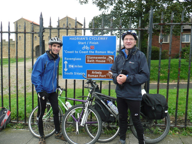
Just after 12 noon we set off in warm weather from the public car park in Ravenglass and cycled the short distance back to the Roman bath house at Glannaventa, the official start point of the ride, for the obligatory photo stop. We thought it was a shame that there weren’t any signs indicating that this was the start of the ride and how far it was etc - especially when we discovered that there was an impressive sign at the finish!
Heading away from the bath house we then made our way over the bridge crossing the sea inlet at Ravenglass and headed along the coastal path - this was as near as we actually got to the sea as the tide was out, so I suppose technically we can’t claim it as a true coast to coast! Our progress along the coastal path was soon interrupted by a puncture (the first of two) but as we had the sun on our backs it wasn’t too much of a problem to fit a new tube (though there was no sign of anything causing a puncture). The signing throughout this part of the route was generally very good and we didn’t have any difficulty in finding our way, we had the wind in our faces as we made good progress along the flat path. After passing through Seascale (a nice seaside village) we turned inland and passed the huge Sellafield nuclear facility. Egremont and Whitehaven, the starting point of the original C2C route were next, followed by a steady but relatively easy climb towards Distington and then Workington. The section between Maryport and Allonby was hard work due to the wind being against us and the partly gravel surfaced coastal cycle path which slowed us down considerably. Just after this we left the quiet coastal road and headed inland before eventually coming back out at the coast again just before Silloth. We felt that this detour was a bit unnecessary as the road which followed the coast (through Mawbray and Newtown) had, until the point the route sent us inland, been very quiet so we could have saved a bit of time and energy had we stayed on the main road (though it is apparently much busier at the weekend).
With the light fading and the chill from the northerly wind more noticeable we rolled into Silloth at around 6.30pm with around 55 miles showing on my speedometer. It was deserted – and with its mix of industry and slightly shabby looking buildings we were quite glad that we hadn’t booked our accommodation here despite it being the recommended Day 1 stop.
[Point of note – there is now only one B & B in Silloth and the Queen’s hotel – which was more expensive, plus we saw very little in the way of places to eat there when we passed through]
A quick check of the map indicated that it was only around 7 miles (or so we thought) to our overnight stop at the Whey-Rigg Hall Hotel (recommended). Riding against the wind we reached a T-junction at Abbeytown. There was no Hadrian’s Cycleway sign (coming from either direction) at this point and as we knew the route turned off left in Abbeytown we turned right to travel the couple of extra miles to our evening stopping point. At this point I had a burst of energy, probably because I knew beer and food awaited us, and sped off in what I thought was the direction of the hotel. Eventually Andrew caught me up and asked why the road signs seemed to be saying that we were getting closer to Silloth, not further away. As it was getting very dark now we had to angle our bike lights to read the map – we soon worked out that we had gone wrong in Abbeytown and ridden about 3 miles in the wrong direction. Tired and cold we turned around and rode back to the centre of the village where we found out where we had gone wrong. Just as we left Abbeytown I felt my back wheel wobble – another puncture (perhaps buying 10 inner tubes for £10 wasn’t such a good idea after all!). Fortunately, there was a street light and a wide pavement nearby where we could fix the puncture. With cold fingers we struggled to get the tyre off the rim but after 10 minutes of swearing we succeeded in forcing a fat mountain bike tube into a skinny road bike tyre. Another two miles of riding in the right direction, brought us to the welcome sight of the pub. After a quick shower we went to the bar and ordered our food and a pint – it was now 9pm!
[Point to note – on arriving at the T-junction in Abbeytown, although you won’t see any Hadrian’s Way signs (unless they have since been replaced), turn left and follow the road for a short way. The signed route goes off to the left at a bend in the road or follow the main road round the bend for about 2 miles if staying at the Whey-Rigg Hall Hotel as we did]
Day 2
After repairing the two punctured tubes and eating every item in our full English breakfasts we set off from the pub at around 10.00am and rode the two miles back to Abbeytown where we quickly picked up the official route at the junction on the bend in the road. The first 10 miles or so were despatched fairly quickly and then we hit the wind again which slowed us down from a steady 12-13mph to about 8-9mph – this was unfortunately a sign of things to come for the next two days. The wind made the area around the peninsular, looking across the Solway Firth, less enjoyable than it should have been and as it had clouded over we couldn’t really see much of Scotland across the water – on reflection perhaps we should have cut the corner between Angertown and Glasson and saved ourselves 12 miles of hard work!
We were soon cycling along a fairly quiet approach road into the centre of Carlisle when we suddenly found ourselves turning left into a busy industrial estate which led down to the riverbank via steps with a “bike channel” running alongside it so that we could push our bikes. The riverside path, which could be slippery and muddy after heavy rainfall, eventually led into Bitts Park and then through Rickerby Park and out of the city centre. We had planned to stop and get some food (our usual Co-op/Sainsbury’s/Tesco £3 meal deal!) in the city centre but before we knew it we had left Carlisle behind (if you plan to stop in Carlisle get off your bike as soon as you come to the end of Bitts Park at an underpass and push through this to the shops). The start of the day’s climbing was at Warwick Bridge and we eventually managed to stop and get some lunch 7 miles later just outside of Brampton (we managed to find a Co-op and a bus shelter to eat our lunch). Unfortunately, the Co-op doesn’t supply spoons with their yoghurts – so we had to use tyre levers instead!! The profile for the rest of the day was generally upwards, particularly just after Lanercost Priory at the appropriately named Banks! It was around this point and at Birdoswald Roman fort that we first saw glimpses of Hadrian’s Wall – it would have been nice to have been able to spend some time stopping at places and reading information signs etc but we didn’t really want to be riding in the dark again so we continued. A few more steep climbs (out of Greenhead in particular) led us into our overnight stop at Haltwhistle. After a few minor navigational errors we found Chare Close B & B (highly recommended) and parked our bikes at about 6pm. The owner, Nick, was very helpful and pointed us in the direction the Black Bull in the market square, where we enjoyed a good pint of hand-pulled beer and a bar meal (and a “character” of a landlord). As we knew we would be pushed for time in the morning we got our obligatory Coop meal deal before returning to the B&B.
Day 3
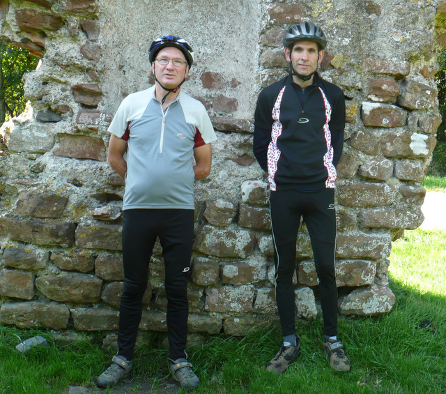
Having done some calculations the night before over a pint we had come to the conclusion that in order to complete the ride (based on an average speed of 10mph) and get back in time for our trains from Newcastle at 6.30pm we would have to leave by 9.30a.m. The weather looked OK as we got ready. While we were having a quick but healthy breakfast (no fryups here!) it started to rain heavily. As we had a deadline to meet we had no option than to saddle up and go. The first hour out of Haltwhistle towards Bardon Mill was relatively straightforward – albeit wet and blustery. The road then climbed up then descended towards Vindolanda Roman fort down a very rough, broken road surface (take care!) before climbing steeply again to the highest point of the ride (867 feet above sea level) at Muckel Moss. We descended and steadily progressed along the Tyne valley through Hexham and then Corbridge (nice place). The next section towards Prudhoe was busier and less pleasant than we had previously encountered and was a reminder that we were getting nearer to Newcastle. The rain had started again and we were beginning to get cold and wet as we cycled along the old railway line past Robert Stephenson’s cottage at Wylam as we looked for somewhere to stop for lunch. Unable to find shelter we carried on then spotted a children’s playground complete with a toy house next to the river. Leaning our bikes next to it we both squeezed inside and ate our Co-op meal deals in (relative) comfort (see photo) and another yoghurt with our tyre levers! Typically, within 100 yards of setting off we came across the Tyne Riverside Country Park Visitor Centre – complete with warmth, shelter, toilets, etc!
The roads became very busy as we approached Newcastle centre via a series of satisfactory but not particularly pleasant cycle paths running alongside busy roads. Soon the many bridges of the Tyne came into view – at this point it felt like we had completed our ride but in fact there was still another 11 miles to South Shields (and another 11 miles back) before we could rest. After cycling along the quayside at Newcastle with all its statues, modern buildings and trendy pavement cafes we soon came to the more “industrialised” sections of the cycle path alongside the River Tyne, with reminders of the ship building and ship repairing industry of days gone by. The Hadrian’s Way signs showing the short distance to go seemed to give our tired legs a bit of a boost (although it might have been the chocolate we kept stuffing our faces with). We quickly rolled down to the Shield’s passenger ferry at North Shields having decided to go for the “proper” finish rather than the alternative at Tynemouth. We needed to get across the ferry and return quickly if were to meet our pre-booked train deadline.
[Point to note – the ferry leaves the north side on the hour and half hour and comes back from the south side at quarter to and quarter past.]
We had a bit of confusion when we got off the ferry at South Shields there wasn’t a Hadrian’s Cycleway sign saying which way to go – just a blue cycleway sign on the left running parallel to the river as you exit the ferry. As we couldn’t see any Hadrian’s Way signs, we followed road signs for Arbeia Fort. We eventually stumbled across what looked like a castle in the middle of a run-down housing estate – our destination – Arbeia Roman Fort! Typically it was closed for the winter season! After having photographs taken of us and our bikes leaning against the railings with the official finish sign behind by a bemused local (way aye man!) we set off back to the ferry with minutes to spare. Once on the North side of the river we then had an hour’s steady but easy ride back to Newcastle city centre (surprisingly, it felt a lot easier cycling back to Newcastle than it did to South Shields) and the rail station before our journey home. We arrived at the station with 30 minutes to spare. Mission accomplished!
Ride Stats
Total distance 202 miles (this included the 12 miles back into Newcastle to catch the train and about 10 miles extra due to our day 1 mistake plus the short extra distance travelling from the Day 1 B & B stop to get back onto the route
Average speed 10.3mph
Total riding time 20h:00m
Summary/Conclusions
Another excellent adventure, well signed with fantastic scenery. In the main very good road surfaces with easily manageable off-road bits (probably OK for most bikes except out and out racers with skinny tyres). Not as hilly as some of the other coast to coast variations but enough of a challenge to make it interesting and manageable enough for most reasonably fit people. A highly recommended route!
Martin and Andrew Webb
October 2013
Having done three coast to coast bike tours in the last three years (the original C2C, the Walney to Whitby and the Way of the Roses respectively) we decided to have a go at the Hadrian’s Cycleway this year. We had considered doing the Reiver’s Route, but as we had heard reports about people getting lost in (and never finding their way out of) Kielder Forest, we thought that the Hadrian’s route was a safer bet.
Day 1
Just after 12 noon we set off in warm weather from the public car park in Ravenglass and cycled the short distance back to the Roman bath house at Glannaventa, the official start point of the ride, for the obligatory photo stop. We thought it was a shame that there weren’t any signs indicating that this was the start of the ride and how far it was etc - especially when we discovered that there was an impressive sign at the finish!
Heading away from the bath house we then made our way over the bridge crossing the sea inlet at Ravenglass and headed along the coastal path - this was as near as we actually got to the sea as the tide was out, so I suppose technically we can’t claim it as a true coast to coast! Our progress along the coastal path was soon interrupted by a puncture (the first of two) but as we had the sun on our backs it wasn’t too much of a problem to fit a new tube (though there was no sign of anything causing a puncture). The signing throughout this part of the route was generally very good and we didn’t have any difficulty in finding our way, we had the wind in our faces as we made good progress along the flat path. After passing through Seascale (a nice seaside village) we turned inland and passed the huge Sellafield nuclear facility. Egremont and Whitehaven, the starting point of the original C2C route were next, followed by a steady but relatively easy climb towards Distington and then Workington. The section between Maryport and Allonby was hard work due to the wind being against us and the partly gravel surfaced coastal cycle path which slowed us down considerably. Just after this we left the quiet coastal road and headed inland before eventually coming back out at the coast again just before Silloth. We felt that this detour was a bit unnecessary as the road which followed the coast (through Mawbray and Newtown) had, until the point the route sent us inland, been very quiet so we could have saved a bit of time and energy had we stayed on the main road (though it is apparently much busier at the weekend).
With the light fading and the chill from the northerly wind more noticeable we rolled into Silloth at around 6.30pm with around 55 miles showing on my speedometer. It was deserted – and with its mix of industry and slightly shabby looking buildings we were quite glad that we hadn’t booked our accommodation here despite it being the recommended Day 1 stop.
[Point of note – there is now only one B & B in Silloth and the Queen’s hotel – which was more expensive, plus we saw very little in the way of places to eat there when we passed through]
A quick check of the map indicated that it was only around 7 miles (or so we thought) to our overnight stop at the Whey-Rigg Hall Hotel (recommended). Riding against the wind we reached a T-junction at Abbeytown. There was no Hadrian’s Cycleway sign (coming from either direction) at this point and as we knew the route turned off left in Abbeytown we turned right to travel the couple of extra miles to our evening stopping point. At this point I had a burst of energy, probably because I knew beer and food awaited us, and sped off in what I thought was the direction of the hotel. Eventually Andrew caught me up and asked why the road signs seemed to be saying that we were getting closer to Silloth, not further away. As it was getting very dark now we had to angle our bike lights to read the map – we soon worked out that we had gone wrong in Abbeytown and ridden about 3 miles in the wrong direction. Tired and cold we turned around and rode back to the centre of the village where we found out where we had gone wrong. Just as we left Abbeytown I felt my back wheel wobble – another puncture (perhaps buying 10 inner tubes for £10 wasn’t such a good idea after all!). Fortunately, there was a street light and a wide pavement nearby where we could fix the puncture. With cold fingers we struggled to get the tyre off the rim but after 10 minutes of swearing we succeeded in forcing a fat mountain bike tube into a skinny road bike tyre. Another two miles of riding in the right direction, brought us to the welcome sight of the pub. After a quick shower we went to the bar and ordered our food and a pint – it was now 9pm!
[Point to note – on arriving at the T-junction in Abbeytown, although you won’t see any Hadrian’s Way signs (unless they have since been replaced), turn left and follow the road for a short way. The signed route goes off to the left at a bend in the road or follow the main road round the bend for about 2 miles if staying at the Whey-Rigg Hall Hotel as we did]
Day 2
After repairing the two punctured tubes and eating every item in our full English breakfasts we set off from the pub at around 10.00am and rode the two miles back to Abbeytown where we quickly picked up the official route at the junction on the bend in the road. The first 10 miles or so were despatched fairly quickly and then we hit the wind again which slowed us down from a steady 12-13mph to about 8-9mph – this was unfortunately a sign of things to come for the next two days. The wind made the area around the peninsular, looking across the Solway Firth, less enjoyable than it should have been and as it had clouded over we couldn’t really see much of Scotland across the water – on reflection perhaps we should have cut the corner between Angertown and Glasson and saved ourselves 12 miles of hard work!
We were soon cycling along a fairly quiet approach road into the centre of Carlisle when we suddenly found ourselves turning left into a busy industrial estate which led down to the riverbank via steps with a “bike channel” running alongside it so that we could push our bikes. The riverside path, which could be slippery and muddy after heavy rainfall, eventually led into Bitts Park and then through Rickerby Park and out of the city centre. We had planned to stop and get some food (our usual Co-op/Sainsbury’s/Tesco £3 meal deal!) in the city centre but before we knew it we had left Carlisle behind (if you plan to stop in Carlisle get off your bike as soon as you come to the end of Bitts Park at an underpass and push through this to the shops). The start of the day’s climbing was at Warwick Bridge and we eventually managed to stop and get some lunch 7 miles later just outside of Brampton (we managed to find a Co-op and a bus shelter to eat our lunch). Unfortunately, the Co-op doesn’t supply spoons with their yoghurts – so we had to use tyre levers instead!! The profile for the rest of the day was generally upwards, particularly just after Lanercost Priory at the appropriately named Banks! It was around this point and at Birdoswald Roman fort that we first saw glimpses of Hadrian’s Wall – it would have been nice to have been able to spend some time stopping at places and reading information signs etc but we didn’t really want to be riding in the dark again so we continued. A few more steep climbs (out of Greenhead in particular) led us into our overnight stop at Haltwhistle. After a few minor navigational errors we found Chare Close B & B (highly recommended) and parked our bikes at about 6pm. The owner, Nick, was very helpful and pointed us in the direction the Black Bull in the market square, where we enjoyed a good pint of hand-pulled beer and a bar meal (and a “character” of a landlord). As we knew we would be pushed for time in the morning we got our obligatory Coop meal deal before returning to the B&B.
Day 3
Having done some calculations the night before over a pint we had come to the conclusion that in order to complete the ride (based on an average speed of 10mph) and get back in time for our trains from Newcastle at 6.30pm we would have to leave by 9.30a.m. The weather looked OK as we got ready. While we were having a quick but healthy breakfast (no fryups here!) it started to rain heavily. As we had a deadline to meet we had no option than to saddle up and go. The first hour out of Haltwhistle towards Bardon Mill was relatively straightforward – albeit wet and blustery. The road then climbed up then descended towards Vindolanda Roman fort down a very rough, broken road surface (take care!) before climbing steeply again to the highest point of the ride (867 feet above sea level) at Muckel Moss. We descended and steadily progressed along the Tyne valley through Hexham and then Corbridge (nice place). The next section towards Prudhoe was busier and less pleasant than we had previously encountered and was a reminder that we were getting nearer to Newcastle. The rain had started again and we were beginning to get cold and wet as we cycled along the old railway line past Robert Stephenson’s cottage at Wylam as we looked for somewhere to stop for lunch. Unable to find shelter we carried on then spotted a children’s playground complete with a toy house next to the river. Leaning our bikes next to it we both squeezed inside and ate our Co-op meal deals in (relative) comfort (see photo) and another yoghurt with our tyre levers! Typically, within 100 yards of setting off we came across the Tyne Riverside Country Park Visitor Centre – complete with warmth, shelter, toilets, etc!
The roads became very busy as we approached Newcastle centre via a series of satisfactory but not particularly pleasant cycle paths running alongside busy roads. Soon the many bridges of the Tyne came into view – at this point it felt like we had completed our ride but in fact there was still another 11 miles to South Shields (and another 11 miles back) before we could rest. After cycling along the quayside at Newcastle with all its statues, modern buildings and trendy pavement cafes we soon came to the more “industrialised” sections of the cycle path alongside the River Tyne, with reminders of the ship building and ship repairing industry of days gone by. The Hadrian’s Way signs showing the short distance to go seemed to give our tired legs a bit of a boost (although it might have been the chocolate we kept stuffing our faces with). We quickly rolled down to the Shield’s passenger ferry at North Shields having decided to go for the “proper” finish rather than the alternative at Tynemouth. We needed to get across the ferry and return quickly if were to meet our pre-booked train deadline.
[Point to note – the ferry leaves the north side on the hour and half hour and comes back from the south side at quarter to and quarter past.]
We had a bit of confusion when we got off the ferry at South Shields there wasn’t a Hadrian’s Cycleway sign saying which way to go – just a blue cycleway sign on the left running parallel to the river as you exit the ferry. As we couldn’t see any Hadrian’s Way signs, we followed road signs for Arbeia Fort. We eventually stumbled across what looked like a castle in the middle of a run-down housing estate – our destination – Arbeia Roman Fort! Typically it was closed for the winter season! After having photographs taken of us and our bikes leaning against the railings with the official finish sign behind by a bemused local (way aye man!) we set off back to the ferry with minutes to spare. Once on the North side of the river we then had an hour’s steady but easy ride back to Newcastle city centre (surprisingly, it felt a lot easier cycling back to Newcastle than it did to South Shields) and the rail station before our journey home. We arrived at the station with 30 minutes to spare. Mission accomplished!
Ride Stats
Total distance 202 miles (this included the 12 miles back into Newcastle to catch the train and about 10 miles extra due to our day 1 mistake plus the short extra distance travelling from the Day 1 B & B stop to get back onto the route
Average speed 10.3mph
Total riding time 20h:00m
Summary/Conclusions
Another excellent adventure, well signed with fantastic scenery. In the main very good road surfaces with easily manageable off-road bits (probably OK for most bikes except out and out racers with skinny tyres). Not as hilly as some of the other coast to coast variations but enough of a challenge to make it interesting and manageable enough for most reasonably fit people. A highly recommended route!
Martin and Andrew Webb
October 2013